
Elementary Surveying & Geomatics, including the 16th edition, provides a foundational understanding of measurement, data collection, and spatial information technologies.
What is Elementary Surveying?
Elementary surveying is the science and art of determining the relative positions of points above, on, or beneath the Earth’s surface. It’s a crucial discipline for establishing boundaries, creating maps, and supporting construction projects.
This field utilizes principles of mathematics, physics, and engineering to accurately measure and represent land features. Modern surveying increasingly integrates digital technologies, like GNSS and total stations, building upon traditional methods. The 16th edition emphasizes these evolving techniques, providing a comprehensive introduction to the core concepts and practical applications of this vital geospatial science.
The Role of Geomatics
Geomatics expands upon traditional surveying, integrating modern technologies for collecting, storing, processing, and disseminating geographically referenced information. It encompasses surveying, remote sensing, Geographic Information Systems (GIS), and related spatial data management techniques.
The 16th edition of “Elementary Surveying & Geomatics” highlights this integration, showcasing how geomatics supports diverse applications – from environmental monitoring and urban planning to resource management and infrastructure development. It’s a multidisciplinary field crucial for informed decision-making in a spatially-aware world, leveraging data for analysis and problem-solving.

Historical Development of Surveying
Surveying’s history spans millennia, evolving from ancient Egyptian land division to modern geomatics, as detailed in “Elementary Surveying & Geomatics” editions.
Early Surveying Techniques
Ancient civilizations, including the Egyptians and Romans, employed rudimentary surveying methods for land boundary demarcation and construction projects. These techniques relied heavily on basic geometric principles and simple tools like ropes, plumb bobs, and sighting instruments. “Elementary Surveying & Geomatics” explores how early methods focused on establishing straight lines and right angles, crucial for agricultural planning and monumental architecture. The accuracy, while limited by technology, was sufficient for their needs, laying the groundwork for more sophisticated approaches. These initial practices demonstrate humanity’s long-standing need to understand and define spatial relationships.
The Evolution of Instruments
Surveying instruments have dramatically evolved over centuries, increasing precision and efficiency. Early instruments, like the groma and dioptra, gave way to the theodolite in the 16th century, enabling accurate angle measurement. “Elementary Surveying & Geomatics” details how subsequent innovations, such as the transit and EDM (Electronic Distance Measurement) devices, revolutionized distance and angle determination. The advent of total stations integrated these functions, and now GNSS technologies offer unparalleled accuracy and automation, transforming modern surveying practices.
Fundamental Principles of Surveying
Core principles encompass accuracy, precision, and error management, vital for reliable measurements; understanding these concepts, as detailed in the 16th edition, is crucial.
Accuracy, Precision, and Errors
Accuracy reflects how closely a measurement approaches the true value, while precision indicates the repeatability of measurements. Surveying inherently involves errors – systematic (consistent deviations) and random (unpredictable fluctuations). Minimizing these errors is paramount. The 16th edition of “Elementary Surveying” thoroughly explores error propagation, adjustment techniques like least squares, and methods for evaluating measurement quality. Understanding these distinctions and applying appropriate error mitigation strategies are fundamental to obtaining reliable and trustworthy survey data. Careful field procedures and rigorous data analysis are essential for achieving both accuracy and precision in surveying projects.
Units of Measurement in Surveying
Surveying utilizes diverse units, historically evolving with regional practices. The foot (US survey foot) and meter remain dominant for distance. Angles are commonly measured in degrees, minutes, and seconds (DMS) or decimal degrees. “Elementary Surveying” (16th edition) emphasizes unit conversions and consistency. Modern surveying increasingly favors metric units for computational efficiency. Proper unit handling is crucial to avoid errors. Understanding relationships between units—feet to meters, for example—is vital. Accurate documentation of units used throughout a project ensures clarity and prevents misinterpretations in calculations and reporting.

Surveying Instruments & Equipment
“Elementary Surveying” details essential tools: tapes, levels, theodolites, total stations, and GNSS systems (GPS, Galileo). Modern equipment enhances precision and efficiency.
Tapes and Chains
Tapes and chains represent the most fundamental tools in surveying, utilized for linear measurement. Historically, chains provided distances in links, while modern tapes offer measurements in feet, meters, or inches.
Understanding tape graduations, corrections for temperature and tension, and proper handling techniques are crucial for accurate distance determination.
“Elementary Surveying” emphasizes the importance of standardized tape lengths and the application of appropriate corrections to minimize errors during measurement processes, forming a basis for all subsequent calculations.
Levels and Leveling Techniques
Levels and leveling techniques are essential for determining elevation differences and establishing vertical control. Instruments range from simple spirit levels to precise digital levels, each offering varying degrees of accuracy.
Common leveling methods include benchmark leveling, differential leveling, and trigonometric leveling, each suited for specific applications and terrain conditions.
“Elementary Surveying” details procedures for minimizing errors like collimation error and refraction, ensuring reliable elevation data, and emphasizes proper setup and observation protocols for consistent results.
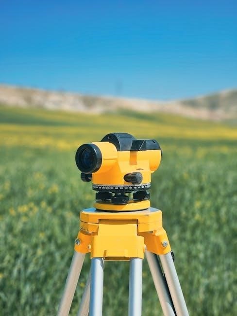
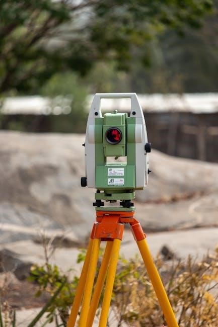
Theodolites and Total Stations
Theodolites and Total Stations represent significant advancements in angle and distance measurement. Traditional theodolites measure horizontal and vertical angles, while total stations integrate electronic distance measurement (EDM) capabilities.
“Elementary Surveying” explains the principles of operation, including angle increment, vernier reading, and EDM phase-shift technology. Modern total stations offer automated target recognition, robotic operation, and data logging features.
Proper instrument setup, calibration, and error management are crucial for achieving high-precision measurements, as detailed within the textbook’s comprehensive guidance.
Global Navigation Satellite Systems (GNSS) ー GPS, GLONASS, Galileo
Global Navigation Satellite Systems (GNSS), including GPS, GLONASS, and Galileo, revolutionized surveying by providing precise positioning data; “Elementary Surveying” details the principles of satellite ranging, signal reception, and positional calculations.
The textbook explains how GNSS receivers determine coordinates based on signals from multiple satellites, addressing concepts like pseudorange correction and differential GPS (DGPS).
Understanding GNSS accuracy limitations, error sources, and data processing techniques is vital for effective integration into modern surveying workflows.

Surveying Methods & Techniques
Surveying Methods & Techniques, as detailed in “Elementary Surveying”, encompass distance measurement, angle determination, traversing, and trigonometric leveling for accurate data collection.
Horizontal and Vertical Distance Measurement
Horizontal distance measurement relies on techniques like taping, chaining, and electronic distance measurement (EDM), crucial for establishing spatial relationships between points. Vertical distance, or elevation differences, are determined through leveling procedures utilizing levels and rods, or trigonometric methods with theodolites and total stations.
“Elementary Surveying” emphasizes the importance of understanding error sources in both horizontal and vertical measurements, including atmospheric effects, instrument calibration, and human error. Precise distance determination is fundamental for accurate mapping, construction layout, and boundary surveys, forming the basis for many surveying applications. Careful procedures and instrument handling are paramount.
Traversing
Traversing is a surveying method establishing control points by measuring angles and distances between them, forming a connected series of lines. “Elementary Surveying” details open and closed traverses, highlighting the importance of angular and linear misclosures. Adjustments, like the compass rule, minimize these errors, ensuring accurate positional data.
Traversing is vital for mapping large areas, establishing boundaries, and creating control networks. The 16th edition emphasizes field procedures, instrument setup, and data recording for precise traverse execution. Understanding traverse computations is crucial for reliable spatial data acquisition and map creation.
Trigonometry in Surveying

Trigonometry forms the mathematical backbone of many surveying calculations, as detailed in “Elementary Surveying.” It’s essential for resolving horizontal and vertical components of distances, calculating angles, and determining inaccessible heights or distances; The 16th edition emphasizes applying trigonometric functions – sine, cosine, and tangent – to field measurements.
Understanding trigonometric principles is crucial for solving problems in traversing, leveling, and triangulation. Accurate angle measurements combined with distance calculations, using trigonometric relationships, yield precise coordinate determinations. Mastering these concepts is fundamental for successful surveying practice.

Data Processing and Adjustment
Data processing, covered in “Elementary Surveying,” involves refining field observations, applying adjustments, and minimizing errors for reliable spatial data.
Field Notes and Data Recording
Meticulous field notes are crucial in surveying, as detailed in “Elementary Surveying & Geomatics.” Accurate recording of observations—distances, angles, elevations—ensures data integrity.
Proper documentation includes sketches, descriptions of points, instrument setups, and environmental conditions. Standardized forms and clear handwriting are essential for minimizing ambiguity.
Digital data collection methods, while increasingly common, still require careful verification and backup procedures. Consistent and organized record-keeping forms the foundation for subsequent data processing and analysis.
Error Propagation and Adjustment
“Elementary Surveying & Geomatics” emphasizes that errors are inherent in all measurements. Understanding how these errors propagate through calculations is vital for assessing data quality.
Least squares adjustment is a powerful technique for distributing errors proportionally among observations, yielding the most probable values. This method minimizes the overall impact of uncertainties.
Proper error analysis involves identifying error sources, estimating their magnitudes, and applying appropriate statistical methods for reliable results and confident interpretations.
Mapping and plan representation, covered in detail, focuses on accurately depicting surveyed features using scales, map projections, and contouring techniques.
Scale and Map Projections
Understanding map scale is crucial; it represents the ratio between distances on a map and corresponding distances on the ground, vital for accurate representation. Map projections transform the Earth’s three-dimensional surface onto a two-dimensional plane, inevitably introducing distortions. Different projections preserve specific properties – area, shape, distance, or direction – depending on the intended application. Common projections include Mercator, Transverse Mercator, and Lambert Conformal Conic, each suited for different regions and purposes. Careful selection of a projection minimizes errors and ensures reliable spatial analysis, as detailed within surveying texts.
Contouring
Contouring represents three-dimensional terrain on a two-dimensional map using lines connecting points of equal elevation – contour lines. Contour interval, the vertical distance between adjacent lines, dictates map detail and readability. Close contours indicate steep slopes, while widely spaced lines signify gentle terrain. Index contours, bolder lines, aid in elevation interpretation. Accurate contouring relies on precise elevation data obtained through surveying techniques. Understanding contour patterns is essential for visualizing topography, planning construction, and assessing land suitability, as comprehensively covered in surveying resources.
Applications of Surveying
Surveying’s diverse applications span construction layout, boundary determination, topographic mapping, and monitoring land changes – crucial for infrastructure and resource management.
Construction Surveying
Construction surveying meticulously controls spatial aspects of engineering projects, ensuring accurate layout of structures, roads, and utilities. This vital process, detailed in resources like “Elementary Surveying,” establishes reference points and verifies dimensions throughout construction phases.
It encompasses setting out building corners, monitoring elevations for grading, and confirming alignment of pipelines. Precise measurements guarantee projects adhere to design specifications, minimizing errors and costly rework. Modern techniques integrate total stations, GPS, and digital levels for enhanced efficiency and accuracy, ultimately contributing to successful project completion.
Land Boundary Surveying
Land boundary surveying, comprehensively covered in texts like “Elementary Surveying,” establishes and re-establishes property lines and corners, crucial for legal descriptions and land ownership. This specialized field relies on historical records, deeds, and precise measurements to define parcel boundaries accurately.
Surveyors utilize techniques like traversing and deed interpretation to resolve discrepancies and ensure compliance with local regulations. It’s a legally sensitive discipline demanding meticulous attention to detail and a thorough understanding of land laws, safeguarding property rights and preventing disputes.
Topographic Surveying
Topographic surveying, detailed in resources like “Elementary Surveying,” focuses on representing the physical features of the Earth’s surface – both natural and man-made. This involves determining elevations, contours, and locations of hills, valleys, rivers, buildings, and other significant elements.
Data collection utilizes instruments like levels, total stations, and increasingly, GNSS. The resulting topographic maps are essential for engineering projects, urban planning, and environmental studies, providing a crucial base for informed decision-making and design.

Modern Trends in Geomatics
Geomatics is evolving with remote sensing, LiDAR, and GIS integration, enhancing data capture, analysis, and visualization capabilities significantly.
Remote Sensing and LiDAR
Remote sensing utilizes sensors to gather data from a distance, offering broad-area coverage and efficient data acquisition for mapping and analysis. LiDAR (Light Detection and Ranging) employs laser scanning to create precise 3D models of terrain and objects, providing highly accurate elevation data.
These technologies, increasingly integrated with traditional surveying methods, enhance efficiency and accuracy in various applications, including topographic mapping, infrastructure monitoring, and environmental studies. Modern geomatics heavily relies on these advancements for comprehensive spatial data collection and analysis, as detailed in contemporary resources.
Geographic Information Systems (GIS) Integration
GIS represents a crucial component of modern geomatics, enabling the storage, analysis, and visualization of spatially referenced data. Surveying data seamlessly integrates into GIS platforms, forming the foundation for informed decision-making across diverse fields.
This integration facilitates advanced spatial analysis, mapping, and modeling, enhancing capabilities in urban planning, environmental management, and resource allocation. Contemporary editions of surveying texts, like the 16th edition, emphasize the importance of GIS proficiency for aspiring geomatics professionals.

Resources and Further Learning
Explore supplemental materials, online resources, and software tools to enhance your understanding of surveying principles, including the 16th edition’s content.
Recommended Textbooks (Including “Elementary Surveying” 16th Edition)
(16th Edition) by Charles D. Ghilani and Paul R. Wolf is a cornerstone resource. This comprehensive textbook provides a detailed exploration of surveying principles and modern geomatics technologies.
Additional valuable texts include those focusing on specific areas like boundary law, advanced adjustment techniques, and GIS integration. Seeking out updated editions ensures alignment with current industry standards and technological advancements. Consider supplementing with practical field manuals for hands-on application of learned concepts.
Online Resources and Software
Numerous online platforms complement “Elementary Surveying” learning. Microsoft’s official download center offers essential software updates. Explore free versions of Microsoft Office (Word, Excel) for report creation and data analysis. Online resources from surveying equipment manufacturers provide tutorials and support. Software like AutoCAD and Civil 3D are industry standards for plan representation. Websites offering practice problems and interactive simulations enhance understanding. Remember to verify the credibility of online sources and prioritize official documentation for accurate information.